


Updated: Sep 13, 2023

Embarking on an epic journey through the rugged landscapes of Torres del Paine National Park is not for the faint of heart. From chaotic bus rides to wild weather swings, this trek was a real test of our resilience. After 8 days and 140km of hiking, we had finally earned the title of ‘hardcore hikers’.
After a 4 hour bus from Argentina to Chile, we found ourselves in the cute port town of Puerto Natales. Nestled on the edge of Chilean Patagonia, Puerto Natales serves as the picturesque gateway town to one of the world's most epic trekking experiences: Torres del Paine National Park.
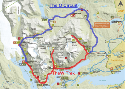
There are 2 popular options for hiking in Torres del Paine National Park. Option 1 is to do the 5 day lower half of the park or “W Trek” that gets its name from the distinctive “W” shape formed by the route on the park map. The other option is to do the full loop or “O Circuit” all the way around the park, starting in a more isolated section, crossing the John Garner Pass then connecting with the W Trek section at the end. This typically takes 8-10 days to complete and is the less popular option due to its greater difficulty. We opted for the full O Circuit, which Jelley had painstakingly booked 3 months ago (the booking systems are horrendous!), and we were excited to be finally embarking on this epic adventure.
Puerto Natales had an atmosphere of eager anticipation as travellers from around the globe were either doing their final errands to prepare for their multi-day trekking experience, or recovering post-hike and sharing stories over a hearty meal and few too many drinks.
We headed down to the local waterfront information centre to try our luck at obtaining some more information about the upcoming trek. Chile continued live up to its reputation of “you’re on your own” in terms of information preparation, but there was a friendly local who kindly gave us a map. It was surprising considering how popular this mountain trek is, but we did feel fortunate to finally have a paper map after fruitless efforts in other regions of Patagonia.
We used our time in Puerto Natales to conquer some preparatory admin tasks. We visited a couple of grocery stores to buy our rations, determined to carry enough food to last the 8 days and avoid the exorbitant prices along the trail. The grocery store had slim pickings (pasta and salami), but we did manage to score some dehydrated meals from a local outdoors shop. Dehy meals were a rarity in this part of the world and, while they came at a hefty price, we were excited to have them as a contingency as a lightweight meal option. Interestingly enough they were the ‘Back Country’ brand, imported from New Zealand.
We had opted for a more budget accommodation in Puerto Natales, which was noticeably more expensive than neighbouring Argentina. It wasn’t until after we heard the constant barking of dogs next door did we realise why the room was so affordable, but the location was great in relation to the bus terminal and town centre, and they agreed to store our additional luggage while we were on our trek, so it was still a win.
Our adventure began with an early morning walk to the bus terminal in total darkness, and we arrived to a hive of activity with hundreds of eager backpackers trying to find their right bus to head out to the popular park. There were around 30 buses leaving in different 5 minute increments, and each ticket was assigned to a specific bus and seat with limited signage.
We met a nice American couple from Hawaii who helped us to navigate the chaos. We didn’t realise at the time, but we would be on the same route for the next 8 days, and we got to know Craig & Charlotte quite well by the end of it! We caught another hour’s sleep on the bumpy bus journey to the park entrance, and awoke to the pouring rain. A rough start to the day especially considering we had about 16km to hike before setting up our tent for the night.
Everyone disembarked from the bus at the park entrance and, in traditional Chilean fashion, no one had any clue what to do or where to go next. It was total chaos. Many of the bus passengers were just on a day trip from town in hopes to catch a glimpse of the famous granite “Torres” (Towers). However, now that they had come all this way and it was pouring with rain they had to make a decision of whether to try their luck and take a further shuttle to the start of the 20km trailhead (which may well be closed by the time they arrived), or turn around and go back to Puerto Natales. This kind of information may have been more useful at 6am before they took the first bus from town.
Luckily for us, Jelley is always 1000% prepared and had read plenty of blogs and articles to know exactly where we needed to be to show our park permit and have cash ready to catch our next 15 minute shuttle to the start of our O Circuit. It seemed unnecessary to have to take 2 buses to get there but as with everything else, “Que Sera Sera”.
We arrived at the start of the trailhead in the pouring rain and howling wind. There was a nice welcome centre to use the bathroom and build up enough courage to set off. We ground our teeth, put on our heavy packs, and set off more drenched than excited.
Day 1: Central to Seron - 14.5km (9mi)
The first few kilometres were a gruelling climb in the mud away from the crowds through sideways rain; a quick glimpse of a double rainbow raised our spirits momentarily. We also ran into Craig & Charlotte from Hawaii again and it was nice to share the cold and misery with company.
After a few hours of walking, the rain finally cleared so we decided to take a lunch break overlooking a beautiful mountain valley. As we sat and ate lunch, a flock of condors descended upon us and put on a gorgeous display of gliding undulations overhead. Chilean condors are large Andean birds of prey known for their impressive size and soaring flight. They are one of the world’s largest flying birds, with wingspans that can exceed 3 metres (or 10 feet). It was a magical site to witness, as 1 condor grew to 30 above us, and we were in awe as they soared above us. A total high on what would’ve otherwise been a pretty miserable day.
We arrived at our first campsite, Camp Seron, which was a grassy meadow in a large valley. It had basic amenities like bathrooms, a cooking area, and a large communal area for hikers to relax and chat. We had opted to camp in our own tent the whole journey but we quickly realized that there were a multitude of more upmarket options for others to make the journey a little enjoyable, including glamping, cabins, fully cooked meals, and even WiFi!! We were a little jealous as we set up our home in the rain, but quickly remembered the difference in price between the options when we had booked and felt satisfied with our decision.
Our neighbouring campers included another Kiwi & American couple! Being such a small country, of course we knew someone in common from back in NZ. Annie & Ben were starting the long journey of moving back to NZ from their home in Canada, with some epic travels and a wedding thrown in along the way. Their hardy friend Kailey had been talked into joining at the last minute, and was battling with her first time backpacking camping. It was great to share stories of our different ‘cultural’ and vocabulary differences.
Day 2: Seron to Dickson - 18.5km (11.5mi)
We woke to cool mountain air and blue skies, able to fully see our surrounds for the first time since arriving at Camp Seron. We decided to take this day a bit slower after yesterday’s early start, and knew there was plenty of trail ahead of us. We basked in the sun’s rays as we walked around a lake and began the steep ascent over a saddle.
As we approached the saddle, the rain returned in a big way, accompanied by hail. We upped the pace, trudging along in the wet until we reached a locked ranger’s station. After a little exploring we found a dome structure to shelter under and enjoy lunch. Another solo hiker joined us, Juliette from Canada. She was courageously taking a gap year after graduating high school and volunteering in various national parks in Chile; super hardcore!
The rain showed no sign of giving up, so we continued on the fairly uninteresting meander through a flat valley until we made it to our second campsite, Dickson Camp. This is probably the fastest we have hiked 18.5km in our lives.
Camp Dickson, a remote haven for hikers, might have had a small kitchen, but it unexpectedly turned into a hub for creating new connections. We all congregated in the tiny shelter as it poured around us and we met with some intriguing fellow adventurers. There was the delightful older couple from Wisconsin, sharing their tales of a lifetime of hikes and how they were tackling the O Circuit one with 2 reconstructed knees and the other with a surgery scheduled on her return. Then, there was the Canadian couple from a tiny town we had stopped in on our 2017 roadtrip, who were just beginning a huge multi-continent adventure, and Kirty & Nathan from the UK who were on a long trip around the world which was going to finish with them moving to Christchurch NZ in September!
Later on, the camp transformed into a pseudo-party with surprisingly rave-like music disrupting the serenity, and laughter and camaraderie echoed into the wee hours. It was somewhat bizarre to have a little shop attached to the camp kitchen, with cocktails and beers on the menu. For those who opted for the premium package, there was the luxury of a separate cabin with a log fire to dry out their boots and gear, a true treat amidst the boggy meadow. Speaking of tents, our trusty shelter, which had seen us through countless nights, had the chance to prove its mettle once more. The Wisconsin couple, residing in a pre-pitched tent supplied by the park, had a more challenging experience, enduring nightly rain showers through leaky doors. But isn't that what hiking is all about? Embracing the unexpected, forming bonds with fellow trekkers, and putting your gear to the test.
Day 3: Dickson to Los Perros - 14.5km (9mi)
With another sunny morning to start the day, we could truly appreciate our location in the Torres Del Paine National Park. It was so persistently wet the day before that even our trusty waterproof boots were soaked and didn’t dry out overnight. Every step felt easier and everything seemed to sparkle a little more around us after the rain. We couldn’t stop smiling today as we gradually hiked up and over a pass, through nothofagus forests and we caught a glimpse of the back side of the Torres in the distance. It was a short day (14.5km), and not super challenging. Just before our next campsite, Los Perros, we approached an incredible glacier which looked like a frozen waterfall. We stopped to reflect on just how lucky we were to be in this corner of the world. We were feeling confident and relaxed after such a cruisy day, and went to bed early before an enormous day ahead - we had no idea what Day 4 had in store for us…
Day 4: Los Perros to Camp Grey, via John Garner Pass - 18.5km (11.5mi)
This would turn out to be the most challenging day of our hiking ‘careers’ to date.
We had been warned the night prior that the latest allowed departure time was 7am. After a night of pouring rain and frustration packing down our gear trying to keep it dry, we were almost the last to leave the campsite. It was pitch black, muddy, and extremely wet as we started a steep ascent through forest, towards the John Garner Pass. As darkness became 'light' (but no sign of the sun) and we emerged from the trees, we were in shock at the winter wonderland ahead of us. The snow started falling, and we continued climbing up toward the ridge line. Thankfully, the hikers before us had paved the way with their footprints - as they they were still in the dark at this stage of their day, we could see where they had gone through the snow into invisible rivers and been absolutely soaked. The Hawaiian couple caught up to us, anxious to not be the last stuck on the treacherous trail alone. We shared our disbelief that the rangers at the campsite had given no warning whatsoever what was ahead of us, and didn’t provide any form of weather forecast/checking hikers were equipped for the conditions/offering the chance to delay a day for better conditions. We reminded ourselves we weren’t in New Zealand.
After 3 hours in treacherous conditions, we approached the ridgeline (1200 metres), hopeful of seeing the promised sweeping views of the 20 kilometre long Grey Glacier below. This was a huge part of the appeal of doing the O Ciruit instead of just the W. Filled with jubilation and a huge feeling of accomplishment reaching the highest point, it was short-lived as we realised it was basically a white-out, enshrouded in fog and clouds and we had to keep moving quickly. We began an icy descent down the pass, losing site of the track from the fresh snow and carving out our own route. Luckily, there were a couple of breaks in the weather and we did get a few glimpses of the mammoth ice sheet which was Grey Glacier below (it’s the bluest grey you’ll ever see!). The massive descent in the slippery snow and mud meant a couple of tumbles, and it was a full body and mind workout to stay focused.
We came across a ranger who was going the other direction, supposedly counting hiker numbers to see if anyone was still stuck on the Pass. We didn’t have high hopes that any rescue would have been initiated if his number didn’t match that of the ranger at Los Perros, but still felt grateful to come across someone else. After a brief conversation, he mentioned “solo tres horas mas”. We were in disbelief. We had already been hiking for 7 hours (and both gained/lost 1000 meters of elevation) and the thought of walking for another 3 hours in this weather felt unimaginable. We were sure we would be less than 1 hour from Camp Grey.
Shortly after this encounter, we arrived at a small refugio under construction, which had an even smaller shelter suitable for a lunch spot. We were absolutely shattered, and feeling deflated at the huge descent still ahead. We felt a little conflicted as to whether to have a quick bite to eat and push on, or take a rest and heat up hot water, have a substantial meal and regroup before continuing. We chose the latter, and absolutely did not regret it. It’s amazing what a hot chocolate, soup, chocolate bar and putting your feet up under a dry shelter for 45 minutes can do after 7 hours in the elements! One common question on a multi-day hike is “what do you wish you had brought with you”? Answer for this one = waterproof gloves. We lost feeling in our cold, wet hands earlier in the day, and used our hot drinks to try to regain a tingle in our fingers.
It felt cruel to make hikers continue this extra distance to Camp Grey, and for any future hikers hopefully this new refugio will be complete by the time you do it!! It would be the perfect place to rest after a challenging 7 hour day (although maybe it wouldn’t be quite as challenging in better weather conditions).
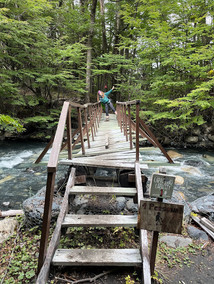
We reluctantly returned to the trail and started the descent. The rain had eased slightly, and we were greeted with epic views of the ice field below us. We crossed 3 absolutely huge swing bridges and hoped like heck they could withstand our body weight as we crossed over canyons far below. It was a huge push, taking us almost another 4 hours, before we arrived at Camp Grey.
An official starting point of the W Trek, Camp Grey was noticeably more developed than our previous accommodations. Accessible by ferry, hundreds of hikers and day trippers were staying in bunk rooms and ready-made campsites. We felt like we were in an alternate reality after our humungous day and 3 days in the relative remoteness, but we were filled with gratitude when we realised this increased accessibility meant a hot shower and full restaurant and bar! Although a little irritated by these clean, dry and energetic tourists, we happily indulged in the home comforts with a pizza and pisco sour, before finally a break in the clouds came, and the sun shone through. This was perfect timing, as all of our gear was rather wet from pitch black pack down that morning, and we were extremely grateful to have a dry tent to sleep in! This was a tough day, and we slept extremely well.
Day 5 : Camp Grey to Paine Grande - 10.5km (6.5mi)
Although we had set our alarms for 8am for a bit of a sleep-in, we woke naturally at 7am and immediately noticed the lack of rain around. We decided to maximise the clear skies and pack down our gear while it was still dry. Asking the rangers of the likelihood of rain, they replied ‘todos los días’ which translates to ‘every single day’. We wanted to get at least some kilometres in before the rain hit. Several of our O Circuit companions were doubling up on a day today, skipping the next campsite and continuing for another 20km. We were both thankful to past Jelley who foresaw that we might be satisfied for a significantly shorter day - just 10km to Paine Grande.
Our bodies were extremely sore, yet the trail was noticeably better maintained and it felt good to walk along a flat, well-formed track with blue sky surrounding us. The track was much busier, and hikers were travelling in both directions, intermingled with day-trippers. The solitude from the days prior felt like a lifetime ago.
We enjoyed the lovely views on the journey, leaving the ginormous Grey Glacier behind us and descended through a valley to Paine Grande. Although in pain, we set a good pace and arrived to camp with drizzle just started to set in, around 12.30pm. After a nice hot lunch of noodles, we waited for a break in the rain to set up our tent for the night. It was truly ‘tent city’ here on the W Trek, this refugio and campsite was well-established and huge. We asked the rangers the total capacity of the 'city', and were shocked at the answer of 300 people per night. The bar had no space, so we checked out the little store which was relatively well-stocked but expensive, with a tube of Pringles costing US$8! We felt happy with our decision to carry our provisions for the full 8 days, despite the weight, and still had our own cookies and chocolate to snack on!
The sun finally came out and revealed the towering craggy peaks around us, it was incredible to finally have a glimpse the famous Torres del Paine. The bright blue glacial lake was gorgeous, and we were happy to chill for the afternoon and rest our legs.
Day 6: Paine Grande to Camp Frances, via Mirador Britanico - 22.3km (13.8mi)
What a day! We woke to the most beautiful sunrise, and we were anxious to hit the trail early for a big day ahead, and potential forecast of rain at midday. It had been super windy overnight, and neither of us slept very well at the busy campsite. Our legs were reallyyy sore today, and we were a little grumpy as we began the walk, stuck behind several larger tour groups.
The wind didn’t really die down at all, but one cool feature of this was huge wind tunnels which formed on the glacial lake we walked around. We took a turn at a trail junction on an non-signposted but established track, and referred to the offline maps on our phone, feeling smug that we’d found a short-cut away from the crowds. Unfortunately, the track led to a completely ruined bridge over a gushing river which was too dangerous to cross. Our destination was clearly visible on the other side of the destroyed bridge, and we cursed ourselves as we backtracked our steps to the main trail junction. It just added one hour extra to our day, but it was an hour we could’ve spent off our feet,
Reaching campsite Italiano, a non-operational campsite but functional shelter and bathrooms, we were happy to ditch our bags under the building and walk free from the weight up to a couple of epic miradors (viewpoints) up the valley. We were greeted with sweeping views of a glacier in the distance at the first lookout, before one final push up to another clearing with extraordinary 360 degree views shortly before Mirador Britanico, and extreme gale-fore winds.
We treated ourselves to 2 Snickers bars to motivate us on the return journey to collect our bags and make it another short 2km to Camp Frances. Located on a steep hillside, our campsite was a platform among the trees. We enjoyed a hot shower, before wandering down to the bar to meet with our fellow O Circuit hikers from Canada & England for a treat at the bar. Nick, Maggie, Vicky & Nathan all ‘had’ to upgrade to the glamping geodesic dome option as the campsites at this spot were all sold out when they booked, and they were quite smug about having the best spot in the house for the night! We were stoked enough with a beer and apple custard pie, before retreating to our trusty tent. We realised this had been our first full day without rain, and went to sleep with a smile on our faces.
Day 7: Camp Frances to Camp Central - 19km (11.8mi)
After a solid 10 hours sleep, we woke to light rain, but good news from the ranger forecast for the following day. Luke successfully deconstructed the tent from the inside for the first time, keeping its contents dry, and we felt rested and happy to be starting day 7! We were a little sad as we knew we were reaching the end of this epic journey, and our legs finally started moving somewhat normally again for the first time since the John Garner Pass. We had lovely views along the waterfront of the glacial lake; amazed at how calm it was compared to the crazy winds the day before. It was a really enjoyable walk, which we shared with several of our hiking companions from the past week together.
We felt accomplished and in awe as we reached Camp Central, right where we started from 7 days prior in sideways freezing rain. We didn’t recognise it in the sunshine! We set up camp for the last time in perfect conditions and had a celebratory pizza and beer with several of our fellow O trekkers - Paul & Catherine from Wisconsin, Nick & Maggie from Canada, Juliette (the 18 year old Canadian on her solo gap year), and a Romanian/Portuguese couple we met more recently who didn’t have a rain jacket with them.
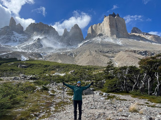
The weather had been so unpredictable on our journey to date that we had written off the chance to go to the base of the Torres, and we were okay with that. The base of this iconic rock formation is generally the main reason travellers from all over the world flock to this stunning national park in remote Patagonia. After our challenging week, we were in luck and the perfect weather window had arrived, and with excellent conditions forecast. We convinced Juliette to join us for this once-in-a-lifetime journey and set our alarms for 230am to hike there for sunrise, one last huge day before our bus back to Puerto Natales.
Day 8: Camp Central to Base of Torres del Paine return - 21km (13mi)
We had no trouble leaving at 3am, and guided by the light of a full moon above, we hardly needed our torches as we hiked the first steep section to Chileno Camp. After a quick hot chocolate, we continued our journey up the valley to arrive at the base of the Torres at 6.45am. It was perfect timing. Dawn was breaking, and started with a bright red hue on the horizon. It was magical as the light began reflecting on the towering torres. It was a truly special moment, and we felt so grateful all of the stars had aligned to allow the perfect conditions to be here on this morning in this moment in time.
It was freezing cold, and as we retraced our steps down the beautiful valley we had hiked up, we felt glad we hadn’t taken the wrong step in the dark now that we could see the steep edges and long way down to the river below us. We were in disbelief we had completed a 21km 7 hour hike and it was only 10.30am!! It was time to take our boots off for the last time, treat ourselves with a burger and empanada and farewell the guanacos who came to see us off on our journey out of Torres del Paine National Park. It felt like we had completed a pilgrimage, and it had been extremely tough. We awarded ourselves the title of officially becoming ‘hardcore hikers’
Our goals when returning to Puerto Natales were shower/laundry/food/wifi/sleep, in any order. While really pleased to have completed the hike, we were arguably more pleased to heading back to these luxuries, and looking forward to the next stage of the trip.
After we had painstakingly booked the campsites along the O Circuit back in November, we also splurged on a 4 day ferry/cruise though the Chilean fjords post-hike back to Puerto Montt, where we had started our long Carretera Austral journey from 6 weeks prior. We were excited for this treat and the perfect post-hike recovery with the promise of penguins, whales, great scenery and sunrise yoga on the deck. The first thing we checked when we connected to wifi was that the departure was on schedule, as it was somewhat notorious for delays. We were extremely gutted to find the ferry had been delayed a minimum of 48 hours. This had thrown our plans into total disarray, as we had allowed 24 hours for delayed, but really couldn’t wait 48 hours or longer, or we’d risk missing our flights back to New Zealand. We really couldn’t push the flights out any later, as Luke had a start date at FIFA to arrive for.
We knew we had to make a new plan, and fast. We were also extremely tired after just 4 hours sleep and the 20km sunrise hike, and our essential needs came ahead of travel logistics. We made the right decision, and extended our stay in Puerto Natales by a night to guarantee a sleep-in and decent wifi, to then make further plans the next day.
When we sorted out out flights to make it to Auckland, NZ the week prior, we weighed up the option of getting back to Santiago and flying Santiago direct to Auckland. The cost of US$4000 per person quickly put us off this option, quick as it may have been. We also had a suitcase stored with Luke’s Mom in California, and it made sense for at least one of us to collect it on the way back. The flights we landed on (at a much more manageable 1200 each) on were:
Puerto Montt -> Santiago
Santiago -> Dallas
Dallas -> San Francisco (30 hours in San Fran)
San Francisco -> Honolulu
Honolulu -> Auckland
Rather than try to rush somewhere else in Chile, we decided to be kind to ourselves and head back to SFO a little earlier and allow 5 days to rest and recover. We were also trying to find somewhere to live in Auckland on our arrival the next week, and Jelley was actively job-hunting. Shout-out to Luke’s Mom for getting the crucial American Airlines flight changed from the US as it was impossible for us to do from Chile.
With that admin finally sorted and a weight off our shoulders, we hobbled next door to an exceptional bakery, then ventured further into town for the best pizza for dinner . Maggie, Nick, Vicky & Nathan were still in town after the O Circuit, and it was great to meet up with them for a farewell drink. We’re still unsure how we didn’t cross paths on the final ascent to the base of the Torres del Paine, but think there was a 15 minute gap between our very similar adventure that day. It was so great to regroup with new lifelong friends with similar values, and we’re so excited for Vicky & Nathan to move to Christchurch! Unfortunately it will be about a week after we leave..
The next day, we packed up, and jumped on the bus down to Punta Arenas to the nearest airport. This truly is the furthest South you can get by road, and we couldn’t believe how close we were to Antarctica! Ironically, we had the best weather on our departure day. A far cry from the sidewinds rain and gusty wind that greeted us 10 days earlier. This would’ve been perfect for our boat journey through the Chilean fjords!
Heading into autumn, it had become so cold in the south, and it was a welcome change arriving to 30 degrees in Santiago! It was a luxury chilling at the pool at the Marriott and being surrounded by home comforts again. It was here that we had a video-call viewing of a potential flat in Auckland and agreed to move-in to a beautiful villa with our new roommates Kim & Krystal the day after we landed in Auckland. It was a bittersweet feeling leaving South America - we still feel we have just scratched the surface of this incredibly diverse continent, and have a lot more on the bucket list to explore in the future.
We were so grateful to have the 5 days in San Francisco on our way through - it would’ve been so rushed with the original planned 30 hours! It was a bit of reverse culture shock as we picked up our rental car, went to Trader Joe’s then cruised up Highway 1 to Stinson Beach again. This had become our new routine when returning to California and it was nice to be in this familiar place again. Our time in the Bay was filled with quality family catch-ups, Stinson sunsets and a whole lot of chilling out.
466 Days after leaving New Zealand, we were on our way back again, to 'settle' in a new city for 6 months. We had decided to keep everything a complete surprise, and hadn’t told any of Jelley’s family or our friends - they weren’t expecting us until Christmas! We look forward to sharing this chapter in our next post.
Until then,

- A Kiwi and A Cali
P.S. This post is written 6 months retrospectively - time flies when you’re back to the work grind! We’ve been and gone from Auckland, and now back home in Christchurch packing our lives up again to fly out on a 1-way ticket again in 5 days .. we have plenty to catch up on from our time here in New Zealand, and promise it won’t be 6 months until the next post.
P.S.S. If you'd like to leave a comment, don't forget to put your name!

Comments